Search results
(41 - 60 of 104)
- Title
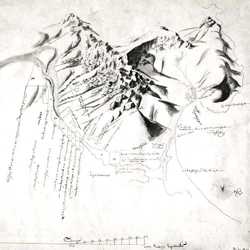
- The Dutch Colony of the Cape of Good Hope
- Subject
- Cape of Good Hope (South Africa) -- Maps -- Early works to 1800.
- Description
- The map shows the area from Klipping Eyland to Caap Falso in False Bay with the Draakenstein mountains as the eastern boundary. The map also depicts the locations of several early settlers, as well as villages, fountains, roads and river crossings., Relief shown by hachures. Depths shown by soundings., Scale in British miles, Dutch miles and nautical leagues.
- Identifier
- islandora:19707
- Title
- Carta geografica de Africa del Capo de bon Esperanze sino al Regno et Imperio Monamotapo e Ria de la Goa. Scoperto dell' Citadino e Commandante
- Subject
- Africa - Cape of Good Hope
- Description
- Across the bottom reads, Landtogt gedaan door de Zuid-Kust van Africa in den Jaare 1781 tot 1793 door Louis Almaro Pisani Burger Commandant en Ingezeetenen der Colonie Zwellendam; Inset of Port Natal., Unknown. Pisani, Almoro Alvise, 1754-1808
- Identifier
- islandora:25324
- Title
- Cape Colony reconnaissance series. Little Bushmanland
- Subject
- Boesmanland (South Africa) -- Maps., Northern Cape (South Africa) -- Maps., Cape of Good Hope (South Africa) -- Maps.
- Description
- Topographical map of Little Bushmanland showing towns and villages, roads, rivers, mountains and other features in the area., Relief shown by contours and hachures., Projection not given., Map folds into an outer cover., Includes index to adjoining sheets., Includes a table listing halting places., Includes: Notes on the intervisibility of signalling stations., Sheet 128-G., Printed on cloth.
- Identifier
- islandora:24927
- Title
- Cape of Good Hope. Kamies Berg
- Subject
- Northern Cape (South Africa) -- Maps., Western Cape (South Africa) -- Maps., Cape of Good Hope (South Africa) -- Maps.
- Description
- Topographical map indicating the Kamies Berg mountain range and towns and villages, roads, railways, rivers, mountains and other features in the Kamies Berg area., Relief shown by contours, form lines and spot heights., Projection not given., Map folds into an outer cover., Includes index to adjoining sheets., Includes a table listing halting places., Includes a general note commenting on: nature of country, roads, rivers, transport, water, supplies and telegraph., Sheet south H-34/M., Maps mounted on cloth and torn slightly along folds.
- Identifier
- islandora:24918
- Title
- The Dutch Colony of the Cape of Good Hope
- Subject
- Africa - Cape of Good Hope
- Description
- The title of the cartouche is on a cliff, nearby are palms, natives on horseback and an elephant; Prime meridian through London., London. Faden, William
- Identifier
- islandora:25244
- Title
- Cape Colony 1896 : adapted from Meteorological Commission's Report, 1886
- Subject
- Rain and rainfall--South Africa--Cape of Good Hope--Maps, Cape of Good Hope (Colony)--Administrative and political divisions--Maps, , ,
- Description
- Map of average rainfall imposed on administrative map, with district and division boundaries, seats of magistracy and railway lines. Chiefly colour. Scale 7/8 inch to 50 miles.
- Identifier
- islandora:29815
- Title
- Cape of Good Hope, Natal & c
- Subject
- Africa - Cape of Good Hope
- Description
- Borders of subdivisions are shown in printed colors; Prime meridian thourgh Greenwich. Bottom left: Weekly Despatch Atlas. 139 Fleet Street., London. Weller, Edward, d. 1884
- Identifier
- islandora:25374
- Title
- No. II. Cape Colony, 1896-7
- Subject
- Sheep farming--South Africa--Maps, Cape of Good Hope (Colony)--Administrative and political divisions--Maps,
- Description
- A map showing the success of sheep dipping carried out according to divisions. It also shows districts and seats of magistracy and railways current as well as those sanctioned and to be constructed. Chiefly colour. Scale 1 inch to 50 miles.
- Identifier
- islandora:25183
- Title
- Map of Cape Colony, 1901
- Subject
- Cape of Good Hope (South Africa) -- Maps.
- Description
- The map shows districts, towns, villages, roads, railways, railways under construction, railway stations and sidings, post offices and postal routes, telegraph offices and lines. Neighbouring areas include the German Protectorate, Gordonia, Vryburg, Orange River Colony, Basutoland, and Transkei., The map is torn along the edges.
- Identifier
- islandora:19588
- Title
- Plan of that portion of the demarcated Zitzikamma forests situated between the Storms River and Blaauw Kranz River in the Division of Humansdorp
- Subject
- Tsitsikamma (South Africa) -- Maps., Cape of Good Hope (South Africa) -- Maps.
- Description
- Plan of the Tsitsikamma Forest showing different forest areas. The plan also gives cadastral details with farm lot numbers, a table of co-ordinates, a table of connections and areas of forests. Included on the table of co-ordinates is a list of areas of farm lots which have to be deducted from the demarcated figure. A note on the plan indicates the portions of forest which have been opened for felling., Lithographed in the Surveyor General's Office., The map has been badly torn and damaged. Some text is missing and there are substantial tears along the folds.
- Identifier
- islandora:19602
- Title
- Cape Colony. Bowesdorp
- Subject
- Northern Cape (South Africa) -- Maps., Western Cape (South Africa) -- Maps., Cape of Good Hope (South Africa) -- Maps.
- Description
- Topographical map indicating Bowesdorp and other towns and villages, roads, rivers, mountains, dunes and other features in the area surrounding Bowesdorp., Relief shown by contours and spot heights., Projection not given., Map folds into an outer cover., Includes index to adjoining sheets., Includes a table listing halting places., The map includes a general note commenting on: nature of country, roads, transport, water, fuel, grazing and supplies., Includes two ancillary maps: Bowesdorp and Garies (scale: 1 in. to 0.5 miles)., Sheet 127-R., Mounted on cloth. Copy 296 is discoloured in places and torn at the bottom.
- Identifier
- islandora:24917
- Title
- Sketch of the Territories on the Vaal River to accompany the Award of His Excellency R.W. Keate Esqre Lieut. Governor of Natal in the arbitration between the S.A. Republic & the Batlapin Baralong & Bangoakelze Native tribes and Nicholas Waterboer, paramount Chief of Griqualand West. Appendix map III
- Subject
- Africans--South Africa--Cape of Good Hope--Administration--Maps, Africans--South Africa--Transvaal--Administration--Maps, Griqualand West (South Africa)--Maps, , ,
- Description
- Map showing boundaries of territories of the Griqua, the Barolong, Bangoaletze and Batlapin tribes, with rivers and some relief shown by hachures. Some colour. Scale 1/8 inch to 10 miles.
- Identifier
- islandora:29804
- Title
- No. III. Cape Colony, 1896-7
- Subject
- Sheep farming--South Africa--Maps, Cape of Good Hope (Colony)--Administrative and political divisions--Maps,
- Description
- A map showing periods of sheep dipping according to divisions. It also shows districts and seats of magistracy and railways current as well as those sanctioned and to be constructed. Chiefly colour. Scale 1 inch to 50 miles
- Identifier
- islandora:25184
- Title
- Le Cape de Bonne Esperance comme il a ete ci-devant
- Subject
- Africa - Cape of Good Hope
- Description
- Similar to Valentijn' s map (see NOR 0215). The mountains are numbered and named in the border. 1. Le chateau. 2. Le Petit-Fort. 3. Montagne du lion. 4. Montagne de la Table. 5. Montagne du Vent. 6. Endroit ou tous les Bataeux Viennent., Leiden. Aa, Pieter van der, 1659-1733
- Identifier
- islandora:25282
- Title
- Wreck of Windsor Castle
- Subject
- Shipwrecks -- South Africa -- Cape Town., Nautical charts -- South Africa -- Cape of Good Hope., Cape of Good Hope (South Africa) -- Maps.
- Description
- Marine chart showing where the Windsor Castle, a 2,672 ton steamer, was wrecked off Dassen Island on 19 October 1876. This chart was specially prepared for the Standard and Mail newspaper. In addition to the site of the wreck, the map shows Camps Bay, Green Point, Mouille Point, the Cape Town docks, Observatory, the Salt River and Riet Vlei, Whale Rock, Robben Island, Blaauwberg and Blaauwberg River, Melkbosch Point, Seal Cove, Matroos Bay and Point, Buffels River, Bok River, Bok Point, Jacob's Cove, Gans Kraal Farm, Black Rock, Moeder River, Darling, Rondeberg, Ijzer Fontein Point, Rondeberg Breaker, and Dassen Island with Roaring Sister, South Rock, South West Breakers, West Ledge, The Triangles, Boom Point and Waterloo Bay., Depths shown by soundings., Projection not given. Map shows a variation of 29°50' between magnetic north and true north., Saul Solomon & Co.
- Identifier
- islandora:19685
- Title
- Cape of Good Hope. De Tuin
- Subject
- De Tuin Region (Northern Cape, South Africa) -- Maps., Northern Cape (South Africa) -- Maps., Cape of Good Hope (South Africa) -- Maps.
- Description
- Topographical map indicating De Tuin and towns and villages, roads, rivers, dunes and other features in the area surrounding De Tuin., Relief shown by contours, form lines and spot heights., Projection not given., Map folds into an outer cover., Includes index to adjoining sheets., Includes a table listing halting places., Includes a general note commenting on: nature of country, roads, drifts, transport, water, fuel, grazing and supplies., Sheet South H-34/I., Copy 332 printed on cloth. Copy 964 mounted on cloth.
- Identifier
- islandora:24928
- Title
- Cape Colony
- Subject
- Railroads--South Africa--Cape of Good Hope--Maps, Railroads--South Africa--Cape of Good Hope--History--Maps, Cape of Good Hope (South Africa)--Maps, ,
- Description
- Map with notes, markings and colourings showing Cape Colony and sorrounding areas, railways, international, provincial and district boundaries, and names of places. Scale: 2.4 in. to 150 miles. Projection not given.
- Identifier
- islandora:29914
- Title
- Cape Colony. Naauwpoort
- Subject
- Naauwpoort Region (Northern Cape, South Africa) -- Maps., Northern Cape (South Africa) -- Maps., Eastern Cape (South Africa) -- Maps., Western Cape (South Africa) -- Maps., Cape of Good Hope (South Africa) -- Maps.
- Description
- Topographical map indicating Naauwpoort and other towns and villages, roads, railways, rivers, mountains and other features in the area surrounding Naauwpoort., Relief shown by contours, form lines and spot heights., Projection not given., Map folds into an outer cover., Includes index to adjoining sheets., Includes a table listing halting places., Includes a general note commenting on: nature of country, roads, transport, water, fuel and grazing., Includes two ancillary maps (scale 1 in. to 0.5 miles): Hanover and New Bethesda. Includes two ancillary maps (scale 1 in. to 1 mile): Middelburg and Naauwpoort., Sheet 129-S., Printed on cloth.
- Identifier
- islandora:24941
- Title
- Cape of Good Hope. Williston
- Subject
- Williston Region (South Africa) -- Maps., Northern Cape (South Africa) -- Maps., Cape of Good Hope (South Africa) -- Maps.
- Description
- Topographical map indicating Williston and other towns and villages, roads, rivers, mountains, dunes and other features in the area surrounding Williston., Relief shown by contours, form lines and spot heights., Projection not given., Map folds into an outer cover., Includes index to adjoining sheets., Includes a table listing halting places., Includes a general note commenting on: nature of country, roads, drifts, transport, water, supplies and towns., Sheet South H-34/U., Mounted on cloth.
- Identifier
- islandora:24920
- Title
- Geological map of the Colony of the Cape of Good Hope, sheet I
- Subject
- Geology--South Africa--Maps, Geology, Stratigraphic--Cape of Good Hope (South Africa)--Maps, Basins (Geology)--South Africa--Maps,
- Description
- Geological map of the Colony of the Cape of Good Hope with notes and lines marked A to F, showing superficial deposits, Ecca and Dwyka Series of the Karoo System, Wittenberg, Bokkeveld and Table Mountain Series of the Cape System, French Hoek beds, Malmesbury Series, dolerite and diabase, and qartz-porphyry granite, railways, roads, rivers, mountains, and pans. Coloured. Scale: 1 in. to 5 English miles. Projection not given.
- Identifier
- islandora:29939
Share