
Search
525 items
-

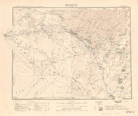
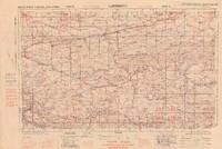
Kenya Colony
Map of Kenya showing parts of Somaliland, Uganda and Tanganyika and territorial boundaries, and Lake Victoria, with railways, roads, tracks,principal towns, centres and administrative posts, villages, settlements, missions, tribal or area names, localities, salt lakes, rivers and watercourses, springs, waterholes, wells, swamps, contours, hill features, cliffs and escarpment, craters, lighthouses, telegraph or telephone lines,aerodromes, landing grounds, seaplane stations, seaplane alighting areas. Colour. Relief shown by form lines, hachures and altitude tints. Sixth edition army/air style. Scale 1 : 2,000,000. -
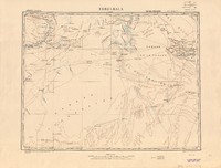
Kerzaz, Colomb-Béchar
Map showing Kerzaz, a town, commune and capital of Kerzaz District in Béchar Province of western Algeria, and military territory boundaries, neighbouring/adjoining boundaries, with automobile tracks, main and secondary roads, permanent water points, temporary water points, wells filled, depth in metres of wells, white blooms gypsum rocks, salt water marshes, dunes with height in metres, sand dunes taking form, longitudinal dunes in the region non elevated, island or board mountains, reinforced towers, mosques, post and telegraph offices, geodetic points, astronomical points, altitude with height in metres, relative side of escarpment, dune, cavity, master and regular curves, landing fields, palm trees, wood and brush. Relief shown by form lines, hachures, height in metres. Colour. Scale 1: 500 000. -

Key map of the Transvaal shewing lands occupied by natives
An administrative map of the Transvaal Colony showing Government locations, private farms owned by natives, undefined locations on private farms and undefined locations on Government farms or crown lands, with district and sub-district boundaries, stations of native and sub-commissioners, stations of resident magistrates and district clerks, all showing district population including foreign labourers, and some railway lines. Some colour. Scale 1 inch to 22.5 miles. -

Kidal
Map of the KidalRegion in Mali, showing international, intercolonial, provincial and district borders. It also shows towns, contours, swamps, rivers with falls, sandy deserts, canals, lakes salt lakes, low ground liable to temporary floods, marsh, oasis, railways, railways under construction, metalled roads, all weather motor roads, seasonal roads, other tracks paths or explorers routes, telegraph and telephone lines along roads and tracks, post offices, wireless telegraph stations, mosques, lighthouses, ruins, water points, wells, mines and quarries trigonometrical points, heights in metres and depths in metres. Relief shown by form lines. Some colour. Scale 1 : 1 000 000. -
Kidal
Map showing the Kidal region in Mali and surrounding regions, with the major cities, place names, roads network and the rivers. Relief shown by shading. Demarcated boundaries highlighted in pink. Colour. Scale1:1,000,000 -
Kidal
A map of Kidal, in Mali, showing colonial and provincial boundaries,with desert trail roads, routes of explorers, villages and towns, flight and landing fields, astronomical points, wells, rivers, water sources, mountains, natural watering holes in the rocks. Relief shown by form lines and hachures. Some colour. Special edition VI. Scale 1 : 500 000. -

Kiffa
Map showing the south-central Mauritanian city of Kiffa and part of the Sudan, and international, intercolonial or mandate, provincial and district boundaries, border subdivisions, with roads and ways for motor traffic, heavy duty roads, light duty roads, nature paths, passable all year round, passable only in dry weather, roads under construction, other tracks paths or explorers routes, telegraph lines along roads, telegraph lines, perrenial rivers: with canals, non-perennial, perrenial water with depths in metres, temporary watering places, swamps, fountains, wells, salt water marshes, airports, flight and landing strips, water airports, post offices and post offices with telegraph or telephones, radio or transmission stations, customs offices, fortifications, ruins, cemetries, graves, palms, tall trees and Baobabs, grasslands, astronomical points, height in metres, relative heights: steep escarpments, dunes, hills, mesa/flat topped hills, stepped terraces, steep edges, sand dunes, basins with sandy ground. Relief shown by form lines and hachures. Some colour. Special edition XII. Scale 1 : 500 000. -

Kindia
Map showing Kindia, the third largest city in Guinea, and international, intercolonial or mandate, provincial and district boundaries, with place names, dual carriage-railways, single carriage railways: standard gauge, narrow gauge, metered tracks, narrow tracks, roads and ways for motor traffic, heavy duty roads, light duty roads, nature paths, passable all year round, passable only in dry weather, roads under construction, other tracks paths or explorers routes, capital of the colony, important city districts, city subdivisions, district capital, villages, military posts, camps, post offices and post offices with telegraph or telephones, customs offices, telegraph lines along roads, telegraph lines on overhead power lines, Christian missions, mosques, minarettes, sanctuaries, lighthouses, radio or transmission stations, watercourses non-perennial, not measured, wells, waterholes, landing strips, highest formlines, formlines not measured. Relief shown by form lines. Colour. Special edition I. Scale 1 : 500 000. -

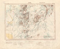
Kita
Map showing the western Mali town and urban commune of Kita, and international, international undemarcated, intercolonial or mandate, provincial and district boundaries, with Dakar, the capital of the colony, and the capital cities of the districts and subdivisions, important city districts, city subdivisions, villages, military posts, camps, Christian missions, mosques, minarets and Moslem sanctuaries, lighthouses, radio and transmission stations, seasonal rivers, unsurveyed rivers, township boundaries, post offices and post offices with telegraph or telephones, customs offices, swamps, fountains, ground liable to flooding, telegraph lines along roads, telegraph lines, roads 1st class, 2nd class, other tracks paths or explorers routes, railways with 1 metre tracks, railways under construction. Relief shown by form lines. Colour. Special edition I. Scale 1 : 500 000. -

Konakri
Map showing Conakry and Sierra Leone, and international, intercolonial or mandate, provincial and district boundaries,with place names, railways with 1 metre tracks, railways under construction or planned, roads and ways for motor traffic, road order of 1st and 2nd category, roads under construction or planned, roads in their natural state, other ways or paths, footpaths, heights in feet above sea level, post offices and post offices with telegraph or telephones, customs offices, telegraph lines along roads, telegraph lines on overhead power lines, Christian missions, mosques, minarettes, sanctuaries, lighthouses, radio or transmission stations, watercourses non-perennial, not measured, wells, waterholes, ground liable to flooding, landing strips, highest formlines, formlines not measured, formlines up to 100m. Relief shown by form lines with height in metres. Colour. Special edition 1. Scale 1 : 500 000. -

Kroonstad
Map showing Kroonstad area in Free State, South Africa, with towns and villages, roads, railways, telegraphs and telephone lines, power lines, lighthouses, aerodromes, water aerodromes, landing fields, bridges, concrete drifts, mines, trigonometrical beacons, spotheights in feet, built-up areas, isolated buildings, police posts, stores, hotels, post or telegraph offices, isolated churches or missions, native kraals, aerial cableways, mountain and hill names, capes, points, rocks, islands, springs, waterholes and wells, rivers or dams, marshes or vleis, pans and lakes, weirs, pipelines and canals, forests, plantations and orchards, rows of trees, natural bush, sugar cane. , vleis, pans and lakes, weirs, pipelines and canals. Relief shown by form lines and spot heights. Colour. Scale 1 : 250,000. -

La Calle
Map showing the port of La Calle, now Qālah or El Kala, on the Mediterranean coast of Algeria, and the surrounding region including Lake Tonga, with state, department, district and town boundaries, national highways, department roads, irregularly maintained carriage roads, paths, logging roads and mule tracks, remains of Roman roads, railways, bridges, ferries, fords, woods, marshes, dunes and sand, vines, water sources dry in summer, churches, chapels and holy places, houses, wells and fountains, water and wind mills, irrigation canals, fixed and rotating lighthouses, port lights, redoubts, batteries, cemetries, trigonometric points, telegraphs, posts. Colour. Relief in hill shading and form lines and contours. Scale 1 : 50.000. -
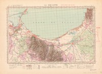
La Goulette
Map of La Goulette, on the Gulf of Tunis, including the Djebel Boi Kournine mountain region, Bordj Cedria-Potinville and Soliman, and state, administrative, district and town boundaries, with magnetic declination, long distance roads, communication routes, local highways, irregularly maintained dirt roads, logging roads and mule tracks, remains of Roman roads, stone bridges, suspended bridges with supports, footbridges, ferries, fords navigable by vehicle or foot, forests, marshes, dunes, vines, water sources dry in summer, churches, chapels or holy places, houses, wells and fountains, water and wind mills, fixed and rotating lighthouses, port lights, redoubts or redouts, batteries, cemetries, irrigation canals, trigonometric points, telegraphs, posts. Colour. Relief in hill shading and form lines and contours. Scale 1 : 50.000. -

La Marsa
Map of region surrounding La Marsa, a coastal town in north-eastern Tunisa opposite the region around Korbous across the sea, showing state, administrative, district and town boundaries, with magnetic declination, long distance roads, communication routes, local highways, irregularly maintained dirt roads, logging roads and mule tracks, remains of Roman roads, stone bridges, suspended bridges with supports, footbridges, ferries, fords navigable by vehicle or foot, forests, marshes, dunes, vines, water sources dry in summer, churches, chapels or holy places, houses, wells and fountains, water and wind mills, fixed and rotating lighthouses, port lights, redoubts, batteries, cemetries, irrigation canals, trigonometric points, telegraphs, posts. Colour. Relief in hill shading and form lines and contours. Scale 1 : 50.000. -
Ladismith
Map showing Ladismith area in the Western Cape, South Africa, with towns and villages, roads, railways, telegraphs and telephone lines, power lines, lighthouses, aerodromes, water aerodromes, landing fields, bridges, concrete drifts, mines, trigonometrical beacons, spotheights in feet, built-up areas, isolated buildings, police posts, stores, hotels, post or telegraph offices, isolated churches or missions, native kraals, aerial cableways, mountain and hill names, capes, points, rocks, islands, springs, waterholes and wells, rivers or dams, marshes or vleis, pans and lakes, weirs, pipelines and canals, forests, plantations and orchards, rows of trees, natural bush, sugar cane. , vleis, pans and lakes, weirs, pipelines and canals. Relief shown by form lines and spot heights. Colour. Scale 1 : 250,000. -
Laghouat, Mascara
Map showing Laghouat, in the Laghouat Department of Algeria, and state/national, military territory and district boundaries, with metalled roads normal routes, metalled roads narrow paths, tramways, under construction, main roads, secondary roads, regularly maintained, paths, trails, perennial rivers/watercourses, non-perennial rivers/watercourses, ravines, aqueducts, wells: source, marsh, capital city, capital towns of districts, villages, hamlets, centre of colonisation, reinforced towers, churches, chapels, mosques, ruins, mines, lighthouses, places by number of inhabitants, isolated places, uninhabitated places, state forests, palm trees. Relief shown by form lines and shading, height in metres. Colour. Scale 1: 500 000. -

Lagos
Map showing the Nigerian port of Lagos and the Bay of Benin, and international, intercolonial or mandate, provincial and district boundaries, with dual carriage-railways, single carriage railways: standard gauge, narrow gauge, metered tracks, narrow tracks, roads and ways for motor traffic, heavy duty roads, light duty roads, nature paths, passable all year round, passable only in dry weather, roads under construction, other tracks paths or explorers routes, telegraph lines along roads, telegraph lines, towns of 1st, 2nd, 3rd, 4th and 5th importance, provincial and district capitals, bridges, ferries, fords, perrenial rivers: with canals, non-perennial, unsurveyed, swamps, wells, waterholes, ground liable to flooding, airports, flight and landing strips, water airports, post offices and post offices with telegraph or telephones, roadhouses, radio or transmission stations, lighthouses, customs offices, harbours, Christian missions, trigonometric or astronomical points, heights and form lines, elevation in metres. Relief shown by form lines with height in metres. Colour. Special edition. Scale 1 : 500 000. -
Lake Abaya
United States Army Air Forces aeronautical chart map showing Lake Abaya in Ethiopia, and parts of Kenya and Anglo-Egyptian Sudan, and state and international boundaries, with landplane facilities, seaplane facilities, lighting facilities, civil airways, air navigation hazards, air defence zones or vital defence areas, radio fan markers, radio marker beacons, non-directional radiobeacons, radio ranges, airport control towers, radio direction finder stations, radiobeacons, radio communication stations, radio broadcasting stations, streams, rivers, lakes and coastlines, rapids and falls, canals, chartered rocks, springs, wells and water holes, tidal flats, glaciers, swamps and marshes, reefs and shoals, all open water areas, mud flats, cities, villages and towns, highways and roads, road markers, power transmission lines, telephone and telegraph lines, dams, highest elevation on chart, spot elevations (in feet), mines and quarries, mountain passes, lookout towers, forts, pipelines, oil fields, race tracks, railroads, railroad sidings, abandoned railroads, railroad overpasses, railroad underpasses, bridges, tunnels, hachures (elevation in feet) sand areas, sand dune areas, sand ridges, unusual land features, washes, contours, approximate contours, depression contours, lava flows, bluffs, cliffs and escarpments. Relief shown by hachures, contour lines with approximate height in feet, tinted shading. Colour. First edition. Lambert Conformal conic projection. Scale 1 : 1,000,000. -
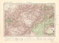
Lake Albert
United States Army Air Forces aeronautical chart map showing Lake Albert in central Africa, on the border between Uganda and the Belgian Congo, and state and international boundaries with Kenya and Anglo-Egyptian Sudan, with landplane facilities, seaplane facilities, lighting facilities, air defence zones or vital defence areas, air navigation hazards, flight lines, civil airways, radio range courses, radio fan markers, radio range facilities, facilities available at airfields, radiobeacons, radio communication stations, radio broadcasting stations, rescue boats, streams and rivers, unsurveyed canals, rapids and falls, intermittent lakes, glaciers, swamps and marshes, shoals, reefs, ledges, sand bars, etc., small coral islands, charted rocks, springs, wells and water holes, mud and tidal flats, cities, towns and villages, highways and roads, road markers, hachures (elevation in feet) sand areas and sand dunes, sand ridges, lava flows, contours, approximate contours, depression contours, bluffs, cliffs and escarpments, power transmission lines, telephone and telegraph lines, dams, highest elevation on chart, spot elevations (in feet), mines and quarries, mountain passes, lookout towers, forts, pipelines, race tracks, railroads, railroad sidings, abandoned railroads, railroad overpasses, railroad underpasses, bridges, tunnels. Relief shown by hachures, contour lines with approximate height in feet, tinted shading. Colour. First edition. Mercator projection. Scale 1: 1 000 000. -

Lake Rudolf
United States Army Air Forces aeronautical chart map showing Lake Rudolf in Kenya with its far northern end crossing into Ethiopia, and state and international boundaries with Italian Somaliland and Ethiopia, with landplane facilities, seaplane facilities, lighting facilities, air defence zones or vital defence areas, air navigation hazards, flight lines, civil airways, radio range courses, radio fan markers, radio range facilities, facilities available at airfields, radio direction finder stations, radiobeacons, radio communication stations, radio broadcasting stations, rescue boats, streams and rivers, unsurveyed canals, rapids and falls, intermittent lakes, glaciers, swamps and marshes, shoals, reefs, ledges, sand bars, etc., small coral islands, charted rocks, springs, wells and water holes, mud and tidal flats, cities, towns and villages, highways and roads: road markers, hachures (elevation in feet) sand areas and sand dunes, sand ridges, lava flows, contours, approximate contours, depression contours, bluffs, cliffs and escarpments, power transmission lines, telephone and telegraph lines, dams, highest elevation on chart, spot elevations (in feet), mines and quarries, mountain passes, lookout towers, forts, pipelines, race tracks, railroads, railroad sidings, abandoned railroads, railroad overpasses, railroad underpasses, bridges, tunnels. Relief shown by hachures, contour lines with approximate height in feet, tinted shading. Colour. First edition Scale 1 : 1,000,000. -

Lake Victoria
Aeronautical chart of the region surrounding Lake Victoria, showing parts of Uganda, Kenya and Tanganyika, and state and international boundaries, with aeronautical symbols, airports, military fields, flight strips, emergency landing fields, seaplane bases and anchorages, beacons, obstructions, mooring masts, lightships, night lighting facilities, marine navigation lights, civil airways, air navigation hazards, air defence zones, vital defence areas, radio facilities and radio ranges, airport control towers, streams, rivers, lakes and coastlines, rapids and falls, canals, one fathom lines, charted rocks, springs, wells and water holes, tidal flats, cities and towns, large, small, towns, villages and stations, glaciers, swamps, marshes, reefs and shoals, open water areas, mud flats, main and secondary roads, power transmission lines, dams, located objects, spot elevation, mines, quarries, mountain passes, lookout towers, forts, pipelines, oilfields, racetracks, railroads, tunnels, sand areas, ridges, unusual land features, depressions, lava flows, bluffs, cliffs and escarpments. Colour. Relief shown by form lines, contours and hachures. Scale 1 : 1.000.000. -

Le Kef
Map of the region surrounding Le Kef in El Kef Governorate, northwestern Tunisia near the border of Algeria, showing state, administrative, district and communal boundaries, with magnetic declination, long distance roads, communication routes, local highways, irregularly maintained dirt roads, logging roads and mule tracks, remains of Roman roads, stone bridges, suspended bridges with supports, footbridges, ferries, fords navigable by vehicle or foot, rivers, forests, marshes, dunes, vines, water sources dry in summer, churches, chapels or holy places, houses, wells and fountains, water and wind mills, fixed and rotating lighthouses, port lights, cannons, cemetries, irrigation canals, trigonometric points, telegraphs, posts. Colour. relief shown by form lines, contours and shading. Scale 1 : 50.000. -

Les Salines
Map of the region surrounding Les Salines in El Kef Governorate, northwestern Tunisia near the border of Algeria, showing state, administrative, district and communal boundaries, with magnetic declination, long distance roads, communication routes, local highways, irregularly maintained dirt roads, logging roads and mule tracks, remains of Roman roads, stone bridges, suspended bridges with supports, footbridges, ferries, fords navigable by vehicle or foot, rivers, forests, marshes, dunes, vines, water sources dry in summer, churches, chapels or holy places, houses, wells and fountains, water and wind mills, fixed and rotating lighthouses, port lights, cannons, cemetries, irrigation canals, trigonometric points, telegraphs, posts. Colour. relief shown by form lines, contours and shading. Scale 1 : 50.000. -
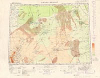
Libyan Desert
Map with hypsometric tints showing region of Libyan Desert on the border of Egypt and Libya,and international, provincial, district boundaries, with oases, railways with gauges, under construction and projected, roads suitable for motor traffic in dry and wet season, motor tracks, desert tracks telephone or telegraph lines, along tracks, mountain ranges, peaks, valleys, capes and islands, tribes, towns of 1st, 2nd, 3rd, 4th and 5th class importance, rivers, unsurveyed water courses, canals, marshes, plains liable to inundation, , minor hill features, geodesic and astronomic points,, water points, historic ruins and wireless telegraph stations, types of sand, aerodromes, landing fields, abandoned aerodromes and landing grounds, seaplane stations, seaplane landing areas, springs, wells Altitude and depth in metres. Colour. Relief shown by contours in metres and hachures. 2nd edition. Scale 1 : 2,000,000. -

Loanda
Map showing region around Luanda in Angola and the Atlantic Coast, and international, intercolonial, provincial and district boundaries, with railways with gauge measurements, under construction and projected, roads suitable for motor traffic, tracks, motorable in some cases, telephone or telegraph lines along roads or tracks, mountain ranges, peaks, valleys, capes and islands, tribes and bridges, towns of 1st, 2nd, 3rd, 4th and 5th class importance, rivers, unsurveyed water courses, canals, marshes and swamps, ground liable to inundation, geodetic trigonometric stations, water points, historical ruins, wireless telegraph stations, and mission stations. Heights in metres. Colour. Relief shown in form lines. 2nd edition. Scale 1 : 2,000,000. -
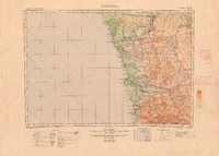
Loanda
Map showing region around Luanda in Angola and Atlantic Coast, and international, intercolonial, provincial, district boundaries, with land aerodromes, landing grounds, marine lights, railways with gauge measurements, under construction and projected, roads suitable for motor traffic, tracks and motor tracks, telephone or telegraph lines along roads or tracks, provinces, districts, localities, mountain ranges, peaks, valleys, capes and islands, tribes, bridges, towns of 1st, 2nd, 3rd, 4th and 5th class importance, rivers, unsurveyed water courses, canals, marshes and swamps, ground liable to inundation, geodetic trigonometric stations, water points, historical ruins, wireless telegraph station,mission stations. Colour with hyposometric tints. Relief shown by form lines. First edition. Scale 1 : 2,000,000. -

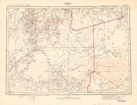
Mabruk
Map of Mabruk, in Mali, showing national, colonial, district and subdivision boundaries,with roads, rivers, waterholes, swamps, flooded areas, sand dunes, salt marsh, mountains, villages, cemeteries and graves, ruins, post offices and telegraph lines, radio stations, customs offices, military posts, astronomical points, landing fields, boabab and palm trees. Relief shown by form lines and hachures. Special edition VI. Scale 1 : 500 000. [Coordinates estimated] -
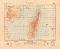
Madagascar
Aeronautical map showing aerodromes, seaplane stations, places for emergency landings, hangars for aiplanes and airships, establishments for inflating balloons, mooring masts, aeronautical markers, aerial and marine lighthouses, international borders, telegraph lines, different terrains and weather stations. Colour. This map also shows part of Mozambique with Lake Nyasa. The map uses Mercator Projection. Edition de février [February edition]. Scale 1 : 3 530 260. [Coordinates estimated] -

Madagascar (Sud)
Map showing south Madagascar and provincial boundaries, with railways, roads, trails, tracks, telegraph and telephone lines, provinces, districts and localities, mountain ranges, peaks, valleys, capes, islands, historical ruins, rivers, watercourses, marshes, wetlands, plains prone to flooding, astronomical geodetic points, and water sources.Colour. Relief shown by form lines and hill shading. Provisional edition. Scale 1 : 2,000,000. -

Main roads of sub-Equatorial Africa
Map showing main roads in Uganda, Kenya, Belgian Congo, Angola, Tanganyika, Northern and Southern Rhodesia, Nyasaland, Mozambique, Bechuanaland Protectorate, South-West Africa and South Africa and frontiers, with place names, mileages, river, lakes and national parks. Scale 1 : 4,000,000. -
Maktar
Map of the region surrounding Maktar, in Siliana governorate, northern Tunisia, showing state, department, district and town boundaries, with magnetic declination, long distance roads, communication routes, local highways, irregularly maintained dirt roads, logging roads and mule tracks, remains of Roman roads, stone bridges, suspended bridges with support, footbridges, ferries, fords navigable by vehicle or foot, foresst, marshes, dunes, vines, water sources dry in summer, state, churches, chapels or holy places, houses, wells and fountains, water and wind mills, fixed and rotating lighthouses, port lights,cannons, cemetries, irrigation canals, trigonometric points, telegraphs, posts. Relief shown by contours and hill shading. Colour. Scale 1 : 50.000. -
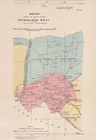
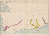
Map no. 1 shewing the relative positions of Griqualand West and the adjoining territories
A map demarcating the boundaries of Griqualand West. Also shows boundaries, rivers, mountain ranges in the Northern Cape. Boundary proclaimed by M. Brand 1870, boundaries of Griqualand West as proclaimed by Sir H. Barkly, 1871. Relief shown by hachures. Colour. Scale 4/8 th inch to 1 mile. Appendix map F -

Map of Cape Colony shewing land reserved for natives
A map of the Cape Colony showing native reserves, locations, mission stations and districts, native reserves, locations and districts under the influence of the Glen Grey Act, with district boundaries, rivers, railways, towns and villages. Some colour. Scale 1 inch to 2 1/2 miles. -
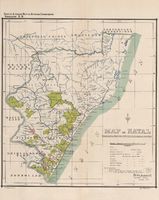
Map of Natal shewing land reserved for and occupied by natives
A choropleth map showing location, mission reserves, county, colony and native land boundaries. Also shows rivers and place names. Some colour. Scale I inch to 22.5 miles. -
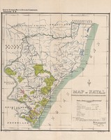
Map of Natal shewing land reserved for and occupied by natives
A choropleth map showing location, mission reserves, county, colony and native land boundaries. Also shows rivers and place names. Some colour. Scale I inch to 22.5 miles. -

Map of part of Cape Colony
A map showing some eastern districts of the Cape Colony, with Division and Magistrates District boundaries, roads, railways, rivers, place names and relief showing by landform drawing. Some colour. No scale given. -

Map of portion of the Malmesbury, Piquetberg and Clanwilliam Districts, to accompany Mr. Hector Shaw's report
A map showing proposed railway lines from Malmesbury through Piquetberg to Clanwilliam, with roads, rivers, place names and relief shown by shading. Some colour. Scale 3/8 inch to 1 mile. -

Map of proposed Mossel Bay and Oudtshoorn Rly
Map showing the proposed railway line from Mossel Bay to Oudtshoorn through the Outeniqua Mountains, with rivers, place names, relief shown by hachures. Some colour. Scale 1:250 000. -
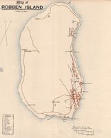
Map of Robben Island
This map of Robben Island shows streets, Varney's Fort, Edmund's Pool, the lighthouse, Ladies' Rock, the slaughter house, Irish town, the boat house, restaurant, convict station, nurses' home, buildings housing the male lepers, tramway, kennels, the White House, buildings housing the female lepers, the quarry, sanitary tip, a spring, the old lime kiln and Wreck House. Also marked in a numbered key are the Chief and Medical Superintendent's quarters, workshops, the parsonage, the English Church, male asylum, a masonry tank, the female asylum. the Assistant Medical Officer, offices, the store, the library and billiard room, the Dutch parsonage, the Magistrate's quarters, the Works Department recreation room, the tram line, water pipes, drains and burial ground. Some colour. Scale 1 inch to 600 feet. -
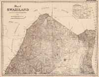
Map of Swaziland. Swaziland north
Map showing the territorial and district boundaries, native areas, rights of way, main roads and paths, footpaths, police posts, post offices, post and telegraph offices, telegraph lines, mission stations, stores, homesteads and mines, "kaffer kraals," railway stations. Relief shown by hill shading. Colour. Scale 1 inch to 1000 Cape Roods, 1 inch to 2.347 English Miles. [Coordinates estimated] -
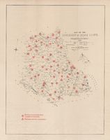
Map of the Division of Hope Town, compiled from general plans & diagrams filed in the Surveyor General's Office, Cape Town, 1894
A map showing existing schools and proposed centres for schools, with divisional boundaries, principal roads, ordinary roads. Some colour. Scale 1 inch to 5 English miles. -
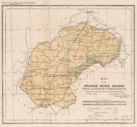
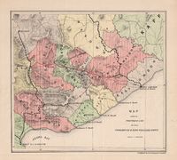
Map of the Orange River Colony shewing land occupied & reserved for natives
A map of the the Orange River Colony showing native locations and 51 farms owned by natives within district boundaries, with towns and villages, rivers, existing railways , railways under construction and proposed railways. Relief shown by hachures and spot heights. Colour. Scale 3/8 inch to 10 miles. Scale 1 inch to 10,000 Cape roods. [Coordinates estimated] -
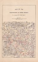
Map of the Queenstown and Indwe District, to accompany Mr. R.T. Hall's report
A map showing elevations, rivers, mountain ranges, roads, railway infrastructure, towns. Relief shown by shading. Scale 1 inch to 5 miles -

Map of the Territory of the Chief Nicolas Waterboer. Extra to the Journal. Copy of Apppendix map II
Map showing the territory of Nicholas Waterboer in Griqualand West, in relation to the Cape Colony, Orange Free State and the Transvaal Republic, with boundaries, rivers, place names and relief shown by form lines. No scale given. -

Map of the Union of South Africa, 1944 = Kaart van die Unie van Suid-Afrika. [Sheet 4 of 4]
Map showing Indian Ocean coast of South Africa and parts of the Orange Free State, Natal and Cape of Good Hope Provinces, and Basutoland, with district boundaries, cities, towns and villages, roads, railways, rivers, air bases, lighthouses and mountains. Some colour. No scale given. -

Map shewing distribution of houses affected by typhoid fever at Port Elizabeth and line of sewers : annexure to report on prevalence
A street map of Port Elizabeth showing typhoid fever cases and the sewers, with street names, rivers, cemeteries, locations, gardens, churches and the synagogue, ponds, dams, parks, the native and pauper burial grounds, jetties, the beach, the railway station and line, the prison, schools and stables. Scale 2 inches to 1000 feet and about 1/2 inch to 100 yards. -
Map shewing railways of Cape Colony, open in 1882
Map of the Cape Colony showing the Western, Midland and Eastern Systems of railways, with an inset of 'Enlarged map of lines near Cape Town.' The System lines show all the train stations and distances. The map also shows towns. Some colour. Scale about 1/2 inch to 10 miles. -
Map showing proposed line between Cookhouse & King Williams Town
A topocadastral map showing a railway line from Cookhouse to King Williams Town in the Eastern Cape. The map shows elevations, district boundaries, roads and railway infrastructure. Colour. Relief shown by hachures. Scale 1:1 000 000
